Planning the Kanchenjunga Base Camp Trek starts with one fundamental question: how far is it from Kathmandu? This is not simply about kilometers on a map. It covers flight time, road journey, days of trekking, altitude gain, and which route reaches the destination faster or at lower cost.
Kanchenjunga sits in the far eastern corner of Nepal, making it one of the most remote trekking destinations in the country. Unlike Everest or Annapurna, reaching this region demands serious planning. This guide breaks down every distance aerial, road, and trail so you know exactly what to expect before the trek begins.
Table of Contents
Where is Kanchenjunga Located?
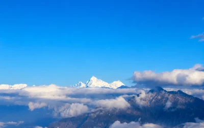
Mount Kanchenjunga is located at 8,586 meters, the world’s third highest peak. It sits in Taplejung District, Province No. 1, far-eastern Nepal, directly on the border with the Indian state of Sikkim.
Its position in the far east places it far outside Nepal’s main trekking corridors. No paved roads lead to the base camp. No shortcuts exist. This is raw, untouched Himalayan wilderness and the distance from Kathmandu reflects that reality.
Understanding the full distance not just aerial kilometers but the complete travel route is the most critical part of planning this trek.
Exact Kanchenjunga Trek Distance from Kathmandu
The aerial straight-line distance from Kathmandu to Kanchenjunga Base Camp is approximately 595 km east of the capital. On a map, it appears reachable. However, Nepal’s geography, deep river valleys, high ridgelines, and winding mountain roads means the actual travel distance is considerably longer.
By road, the distance from Kathmandu to Taplejung, the trek’s starting point, is approximately 700 to 750 km. This route winds through the Terai lowlands and the hill districts of eastern Nepal.
From Taplejung, trekking begins. Depending on whether the destination is South Base Camp or North Base Camp, the trail covers an additional 110 to 140 km on foot through remote mountain terrain.
In total, from Kathmandu to Kanchenjunga Base Camp, the combined travel and trekking distance reaches approximately 800 to 900 km.
How to Reach Kanchenjunga Base Camp from Kathmandu
Three routes connect Kathmandu to the trek starting point of Taplejung. Each differs in distance, travel time, cost, and reliability.
1. By Flight – Fastest Route
The quickest way to cover the distance between Kathmandu and Kanchenjunga is a domestic flight to Suketar Airport, also known as Taplejung Airport.
- Route: Kathmandu to Suketar (Taplejung)
- Flight Duration: 35 to 40 minutes
- Suketar to Taplejung town by jeep: 30 to 45 minutes
- Total time from Kathmandu to trek start: Half a day
A trekker can leave Kathmandu in the morning and stand in Taplejung by midday. However, Suketar is a mountain airstrip and flights are highly weather-dependent. Cancellations and delays are common, particularly during monsoon season.
Verdict: Fast but expensive and subject to weather delays.
2. By Road – Budget Route
For trekkers prioritizing budget over time, the overland bus or jeep route is the most economical option.
- Route: Kathmandu to Itahari to Dharan to Basantpur to Taplejung
- Total road distance: approximately 700 km
- Travel time: 18 to 22 hours of driving, typically split over 2 days
- Common overnight stop: Dharan or Basantpur
The road passes through the flat Terai plains before climbing steeply into the eastern hills toward Taplejung. The final stretch from Basantpur to Taplejung alone takes 6 to 8 hours on winding mountain roads. Road conditions are reasonable in the dry season but deteriorate significantly during monsoon.
Verdict: Lowest cost option but slow, physically tiring, and adds 2 full days of travel.
3. Combined Route – Most Practical Choice
The most widely used route among trekkers combines a short domestic flight with a jeep ride.
- Route: Kathmandu to Bhadrapur by flight, then Bhadrapur to Taplejung by jeep
- Kathmandu to Bhadrapur flight: approximately 1 hour
- Bhadrapur to Taplejung by jeep: 180 km / 5 to 6 hours
- Total travel time: approximately 1.5 days
Bhadrapur Airport serves the eastern Terai and operates more frequent and reliable flights than Suketar. From Bhadrapur, a jeep covers the remaining distance through the hills to Taplejung. This route balances travel time, cost, and flight reliability effectively.
Verdict: Best balance of time, cost, and reliability the route most trekkers choose.
Flight vs Road vs Combined Distance and Route Comparison
Planning your Manaslu Circuit Trek? Choosing the right route to reach the trailhead can save time, cost, and effort. Here’s a quick comparison of the main travel options to Suketar:
| Route | Distance | Travel Time | Cost Level | Best For |
| Direct Flight to Suketar | ~595 km by air | Half a day | High | Trekkers with limited time |
| Full Overland by Road | ~700 km by road | 2 full days | Low | Budget-focused trekkers |
| Flight to Bhadrapur + Jeep | ~595 km air + 180 km road | 1.5 days | Medium | Most trekkers |
Direct answer: If time is the priority, fly to Suketar. If budget is the priority, take the overland road. For the best balance of both, fly to Bhadrapur and jeep to Taplejung.
Taplejung to Kanchenjunga South Base Camp Distance
From Taplejung, the trail to Kanchenjunga South Base Camp passes through dense forests, river valleys, and high alpine terrain before reaching the base camp below the dramatic south face of Kanchenjunga.
- One-way trekking distance: 110 to 120 km
- Total walking days: 10 to 12 days
- South Base Camp altitude: 4,780 meters
Key trail stops: Taplejung → Mitlung → Chirwa → Sekathum → Amjilassa → Gyabla → Ghunsa → Tseram → Ramche → South Base Camp (Oktang)
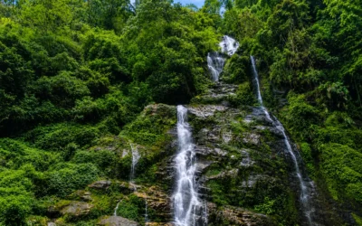
The trail passes through the Kanchenjunga Conservation Area and traverses villages of the Rai and Limbu communities, offering cultural depth alongside the mountain scenery.
Taplejung to Kanchenjunga North Base Camp Distance
The trail to Kanchenjunga North Base Camp, locally called Pangpema, is longer and reaches a higher elevation than the south route.
- One-way trekking distance: 130 to 140 km
- Total walking days: 12 to 14 days
- North Base Camp altitude: 5,143 meters
Key trail stops: Taplejung → Mitlung → Chirwa → Sekathum → Gyabla → Ghunsa → Kambachen → Lhonak → Pangpema (North Base Camp)
The north route ascends through the high-altitude valley of Ghunsa, past glacial moraines and frozen lakes, to the Pangpema viewpoint. From there, trekkers face a direct view of the massive north face of Kanchenjunga alongside Jannu (Khumbhakarna) peak.
Kanchenjunga Base Camp Altitude and Total Elevation Gain
In mountain trekking, vertical distance matters as much as horizontal distance. The elevation gain from Kathmandu to both base camps determines the acclimatization schedule and overall physical demand of the trek.
| Point | Altitude |
| Kathmandu | 1,400 m |
| Taplejung | 1,820 m |
| Ghunsa | 3,595 m |
| Kanchenjunga South Base Camp | 4,780 m |
| Kanchenjunga North Base Camp | 5,143 m |
From Kathmandu to North Base Camp, the total elevation gain is approximately 3,743 meters. This is why proper acclimatization days are built into every itinerary. Gaining altitude too quickly is the primary cause of altitude sickness on this trek.
Day-by-Day Distance Breakdown: Kanchenjunga Base Camp Trek Itinerary
This detailed Kanchenjunga Base Camp trek itinerary shows the daily trekking distances, walking hours, and routes from Taplejung to both the North Base Camp and South Base Camp. Use this guide to plan your trekking pace, rest stops, and accommodations along the Kanchenjunga Circuit.
| Day | Route | Distance | Walking Hours |
| Day 1 | Kathmandu to Taplejung (fly or drive) | ~595 km aerial | Travel Day |
| Day 2 | Taplejung to Mitlung | ~14 km | 5–6 hrs |
| Day 3 | Mitlung to Chirwa | ~12 km | 4–5 hrs |
| Day 4 | Chirwa to Sekathum | ~10 km | 4–5 hrs |
| Day 5 | Sekathum to Amjilassa | ~11 km | 5–6 hrs |
| Day 6 | Amjilassa to Gyabla | ~12 km | 5–6 hrs |
| Day 7 | Gyabla to Ghunsa | ~10 km | 4–5 hrs |
| Day 8 | Ghunsa to Kambachen | ~13 km | 5–6 hrs |
| Day 9 | Kambachen to Lhonak | ~10 km | 4–5 hrs |
| Day 10 | Lhonak to Pangpema (North Base Camp) | ~8 km | 4 hrs |
| Day 11–12 | Pangpema to Ghunsa (Return or Crossover) | ~31 km | 2 days |
| Day 13–15 | Ghunsa to Tseram to South Base Camp | ~40 km | 3 days |
This itinerary covers the full Kanchenjunga Circuit both South and North Base Camps. Trekkers choosing only one base camp will complete the journey 3 to 5 days earlier. To ensure a safe journey, many ask is the Kanchenjunga Base Camp trek safe; with proper planning, it is a secure adventure for experienced hikers.
Total Distance:
The Kanchenjunga Circuit Trek is one of Nepal’s longest and most remote trekking routes, covering both South and North Base Camps. Trekkers experience over 220 km of continuous wilderness, making it a truly off-the-beaten-path adventure. Below is a detailed breakdown of distances and durations for planning your trek:
| Section | Distance |
| Kathmandu to Taplejung (by air) | ~595 km |
| Taplejung to South Base Camp (one way) | ~110–120 km |
| Taplejung to North Base Camp (one way) | ~130–140 km |
| Full Circuit Trek (South + North combined) | ~220–250 km |
| Total days from Kathmandu (full circuit) | 20–24 days |
Key Highlights:
- Covers both South and North Base Camps of Kanchenjunga.
- Offers one of the longest continuous wilderness treks in Nepal.
- Ideal for trekkers seeking remote, off-the-beaten-path Himalayan experiences.
Best Time to Trek: How Season Affects Distance and Access
Season selection directly affects how practical or difficult it is to cover the distance between Kathmandu and Kanchenjunga Base Camp.
Spring (March to May) is the strongest overall season. Roads are in good condition, domestic flights operate consistently, and trails are clear. This is the primary trekking window for Kanchenjunga.
Autumn (September to November) is equally strong. Post-monsoon skies are clear, mountain views are at their best, and both flights and roads are reliable.
Monsoon (June to August) makes the overland road to Taplejung difficult and at times impassable. Landslides block roads, adding unpredictable travel days. Flights to Suketar face frequent cancellations. The effective travel time and distance increase considerably. This season is not recommended for this trek.
Winter (December to February) allows trekking on lower sections but brings harsh conditions above 4,000 meters. Flights and roads are generally operational, but the high-altitude sections near both base camps become demanding in cold and snow.
Conclusion
Kanchenjunga is not a destination close to Kathmandu. From the capital, the aerial distance alone is 595 km. Add road travel to Taplejung and then 110 to 140 km of trekking on foot the total combined distance reaches 800 to 900 km depending on the route and base camp chosen. The full circuit covers 220 to 250 km of continuous mountain trail.
Route choice depends on priorities. A direct flight to Suketar covers the distance fastest. The overland road covers it at the lowest cost. The combined flight to Bhadrapur with a jeep to Taplejung delivers the best balance of time and cost the route most trekkers select.
Season matters. Spring and autumn keep roads open, flights running, and trails clear. Monsoon adds travel days and risk to every section of the journey.
Kanchenjunga demands preparation. Trekkers who plan the distance carefully, respect the elevation gain, and allow adequate days on the trail will find one of the most rewarding and unspoiled trekking experiences in the Himalayas. Before leaving, make sure to check what gear is essential for the Kanchenjunga Circuit trek to be fully prepared for the remote environment.
Frequently Asked Questions
How far is Kanchenjunga from Kathmandu?
Kanchenjunga is approximately 595 km from Kathmandu by straight-line aerial distance, and around 700 to 750 km by road to the trek starting point of Taplejung.
How many days does it take to reach Kanchenjunga Base Camp from Kathmandu?
Including travel and trekking, it takes 12 to 16 days to reach either South or North Base Camp from Kathmandu. The full circuit covering both base camps takes 20 to 24 days. Can older trekkers complete the Kanchenjunga Circuit trek? Yes, with a well-paced 25-day itinerary, it is very achievable for fit seniors.
What is the closest airport to Kanchenjunga Base Camp?
Suketar Airport in Taplejung is the closest airport to the trek. It is 35 to 40 minutes by domestic flight and is the fastest point of entry for trekkers.
Which route is the fastest from Kathmandu to Kanchenjunga?
A direct domestic flight from Kathmandu to Suketar Airport. The trekker reaches Taplejung in half a day. Flights are weather-dependent and more expensive than other options.
Which route is the cheapest from Kathmandu to Kanchenjunga?
The full overland road by bus or jeep: Kathmandu to Taplejung via Dharan and Basantpur. It costs considerably less than flying but requires 2 full days of road travel.
What is the altitude of Kanchenjunga Base Camp?
Kanchenjunga South Base Camp sits at 4,780 meters. Kanchenjunga North Base Camp (Pangpema) sits at 5,143 meters. For detailed lodging info at these heights, see our Kanchenjunga trek accommodation guide.
What is the total trekking distance of the Kanchenjunga Circuit Trek?
The full circuit covering both South and North Base Camps is approximately 220 to 250 km of total trekking distance from Taplejung.